Lake Tahoe Circumnavigation
Trip Report September 10-15, 2008
by Win Aldrich
Thanks to the initiative and planning by Pam and Bill Schlotter for this trip, the Motley Crew of Pam and Bill Schlotter, Trent Ward, Steve Richie, John Clinton, John Faas, Dick Brannin, and Win Aldrich rose to face the challenge and fun- and it was a fun trip.
Resources:
1. Lake Tahoe Water Trail: http://www.laketahoewatertrail.org/ and helpful suggestions from Dennis Liebl, Chairman of the Lake Tahoe Water Trails Organization
2. Lake Tahoe Water Trail Map and Guide- available throughout Lake Tahoe https://laketahoewatertrail.org/explore-water-trail/ltwt-map-and-guide/
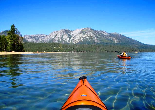
The Lake itself is at 6226 feet and is reported to be 72 miles around. The water is spectacularly clear, and we were fortunate to have extremely calm wind and wave-free weather. The weeks before had been capped by 30-40 mph winds out of the South with reportedly 8 foot waves on the North Shore., and the week after our trip was blessed with rain squalls and wind again. One must always expect unsettled conditions on Lake Tahoe and we had scheduled in several extra days if we needed to layover- which we did not need to do- although we paddled a very leisurely pace to enjoy the company and scenery. The Lake itself is surprisingly sterile and devoid of apparent life in terms of fish and plant life in the shallows as we paddled along the shore. There were a few early morning fishermen out on the lake several days, but this being after Labor Day, the Lake was almost devoid of any boat traffic during the weekdays, and surprisingly light on the weekend. Our intent was to make this a fun trip, and we were not scheduled to break any speed records or to make this a wilderness trek- as evidence by our eating at several restaurants, staying at well-equipped campgrounds and even one night at the Hyatt-Regency at Incline Village. For those looking for an even more urbane trip- this one could also be made as a lodge-to-lodge trip without problems. We made the trip in the clockwise direction although it is usually suggested that a counterclockwise route be taken. We chose to do this to put the shorter passages in the front part of the trip to flush out our readiness and allow us to condition ourselves for the longer last day. For us this worked very well. The campgrounds we used were all well equipped and convenient- although all of them required quite a haul from the beach landing which added significantly to the time of camp set-up and morning breakdown loading and launching.
Tuesday September 9, 2008
We gathered at Zephyr Cove Resort and Marina on the southeast shore of Lake Tahoe the night before launching to meet together for the first time as a group and to finish last minute purchases and planning for our big excursion. Several of us had dinner at the restaurant at Zephyr Cove, while the remainder cooked back at the campsite. Coincidently, Kathy and Henry Pilcher in their new RV along with George Manolakas and Lynn Haskell were camped next to us getting ready for several days of paddling along the East Shore. The winds during the day had been quite high out of the South with white caps off shore and it was not clear what we would encounter in the morning.
Wednesday September 10, 2008
Zephyr Cove Resort and Marina-to Camp Richardson 9.33 miles
We set out after getting up at 6:00 am and packing our kayaks for the first time and finally launching at 9:15 with all but Bill Schlotter who was suffering from a reverse case of Montezuma’s Revenge. He agreed to drive on ahead to Camp Richardson to meet us there and help us all haul our kayaks and equipment from the sandy beach landing to the Badger’s Den campground. The morning was calm and beautiful as we paddled along by Zephyr Point, Marla Bay (where Pam had to make one of her many pit stops) and Elk Point in Nevada as we crossed the state line into California, South Lake Tahoe and continued past where the Upper Truckee River dumps into Lake Tahoe and formed a large shallow sandbar off shore where the winds picked up out of the Northeast which coupled with the shallow water gave rise to our first and only choppy waves of the trip. The mostly developed area was backed by the looming casinos at Stateline framed by the ski slopes at Heavenly on Monument Peak to the Southeast. We then passed Tahoe Keys and the beautiful Pope Beach (where Pam stopped again). Both Steve Richie and John Faas were struggling at this point and pretty much decided that they were not equipped well enough nor in shape to do the whole trip. We landed at the front of the Beacon Grill and the dock at Camp Richardson, and Bill was there to help us all haul ourselves up the ~1/3 mile to the campground which was beautiful, with sugar pines and soft grass campsites. Nobody else was there and we pretty much had the campground to ourselves except for a number of enthusiastic young teens who whooped it up with their singing and exuberance. Again several of us again partook of the Beacon Bar and Grill for a wonderful dinner as well as their famous Rum Runners-a great way to cap off our first day out. This night was the only really cold night on the trip-it got down to 28 degrees F just before sunup, but warmed up quickly and the rest of the days were in the 70’s and nights in the 40’s and 50’s.
Thursday September 11, 2008
Camp Richardson around Emerald Bay to D. L. Bliss State Campground-10.6 miles
We again were all up at 6:00 am and after breakfast and hauling our gear and kayaks back down to the beach launch we were off at 8:30 am this time accompanied by Bill Schlotter. John Faas and Steve Richie lingered in camp and packed up and headed over to D.L. Bliss Campground in their car after Bill had shuttled them back to Zephyr Cove to retrieve it and leave his van for our eventual return.
The 6 of us paddled first along the historic Tallac Historical Site (NFS) of former summer cottages of the rich and famous- the Popes and Lucky Baldwin, etc., along Kiva Beach, Baldwin Beach which along with Pope Beach of the day before are restricted to beach-goers and human powered boats- no power or sail boats allowed. They are backed by old growth sugar pines while the remainder of the Lake is all fringed by second growth-hard to imagine that all of this had been clear-cut logged for the silver mines in Nevada at the end of the 1800’s, it is spectacular. After the secluded beaches on the South Shore we paddled by the developed area south of Eagle Point around which we passed and headed into the undeveloped and beautiful Emerald Bay which is part of the State Park System. At the far end of the Bay is the State staffed “Vikingsholm’ a reconstruction of a traditional Viking castle/home build as a summer home by Mrs. Lora Josephine Knight in 1929 and later donated to the State Park system of California. Emerald Bay also includes the only island on Lake Tahoe- Fanette Island, and there is available a paddle-in only campground at the Emerald Bay Boat Camp as well as camping at Eagle Point Campground. We circled around Emerald bay clockwise stopping at Vikingsholm for a snack and rest break and then headed out as the excursion paddlewheeler from Zephyr Cove steamed in and we headed up along the beautiful undeveloped palisades along D.L. Bliss State Park heading for Rubicon Point to round into the campground beach. We locked the kayaks at the beach and headed up a steep mesa to the campground which afforded a fantastic overview of the Lake-the prettiest of the trip. John and Steve joined us here for the night and they were going to paddle back to Emerald Bay the next day to enjoy it.
Friday September 12, 2008
D.L. Bliss State Campground to Meeks Bay Resort and Campground-3.17 miles
This day was a short paddle to Meeks Bay- but after all the stories we had heard we wanted to see this site also. We had also built in extra time here if needed in case of bad weather, and had planned to spend two nights, but because the weather was so good we only spent the one night and decided to head on around the Lake.. The camp hosts here were much in evidence and very pleasant. However, the campsites were far from the water and quite a haul with the equipment as well as close to the road and somewhat noisy during the night. Most days we got to the next campsite between 12:00 noon and 1:00 pm, but today because the trip was so short, many of us went back to the beach to play in the water with our boats, with several doing some rolling practice. In spite of what people said- the water was not that cold- refreshing actually. There was no restaurant available here, so alas we had to actually cook our dinner.
Saturday September 13, 2008
Meeks Bay Resort and Campground to Lake Forest Campground -12.8 miles
Today’s paddle continued up the West side past developed areas that were enjoyable with the mountains ridges backdropping the coast as we passed Sugar Pine Point, Tahoma, Homewood, crossed McKinney Bay, Tahoe Pines, Sunnyside, Tahoe Park, and the relatively busy Tahoe City as we headed for the Lake Forest Campground. The Truckee River empties out of Lake Tahoe at Tahoe City and we could just see it’s location as we passed by. The Tahoe State Recreation Area Campsite was closed at this time of year after Labor Day, but the Lake Forest site with the ramp next to the Coast Guard Station (yes there really is an official Coast Guard Station on Lake Tahoe) was adequate but certainly the least desirable of all the sites we stayed at. This was the one location that was actually crowded in that the only spot to take out was crowded with people launching and landing powerboats this being Saturday. A highlight of the night was the ¼ mile walk to Bacchi’s Inn which we discovered- they serve a famous 5-course Italian menu family style in an old inn and it was wonderful.
Sunday September 14, 2008
Lake Forest Campground to Incline Village /Hyatt-Regency-13.9 miles
This was one of the longer days, but not the longest as we headed across the Northern end of the Lake. It continued to be warm, clear, and calm as we rounded Dollar Point crossed Carnelian Bay past Cedar Flat towards Flick Point, across Agate Bay off Tahoe Vista, and Kings Beach which were busy on shore with Sunday revelers but few boats on the water. We then passed Brockway were we saw a towed paraglider behind a boat as we passed Brockway and rounded Stateline Point with beautiful rock formations on the point, and again a towering casino. We inadvertently split up into two groups at this point as Pam had to speed ahead for a much needed pit stop, but the homes along Crystal Bay were perhaps the most attractive in that they reflected more the old time look that one would expect from Lake Tahoe rather than the more modern or mid century look of the rest of the developed areas. As we approached the Hyatt it definitely had the look of Club Med what with all the young things wandering around in butt floss bathing suits. The cultural shock of a HR Convention going on, a 12 story hotel with casino and restaurants, 6 pillows per bed, and the Mercedes running around with the top down and the gold encrusted over- the-hill-gang with trophy wives and girlfriends took us by surprise, but it was a nice respite- the food was good, the drinks strong, and the beds comfortable. We elected to be up for a 7:00 am launch in that the 18+ miles along the Eastern Shore was going to be long day.
Monday September 15, 2008
Incline Village/Hyatt-Regency to Zephyr Cove Resort and Marina- 18.2 miles
Well, we did make an early start as we took off in the early morning shadows of the mountains to the east. By far this was the most spectacular part of the trip what with the totally undeveloped NFS lands for most of the way coupled with large house-sized boulders dotting the beautiful sandy beaches, as we passed Sand Harbor/Point, Historic Thunderbird Lodge, Secret Harbor, Skunk Harbor, Deadman Point, Glenbrook Bay with it’s exclusive gated community, South Point, Cave Rook, and on into Zephyr Cove again. We has brief spurts of wind, but nothing bad, and we stopped about every 2 hours at some of the most beautiful beaches- Chimney Creek Beach being the most memorable. It was a long paddle but we managed to stay together- including Trent Ward who I should mention was much younger that the rest of the Motley Crew, but he was paddling a very high freeboard Malibu fishing sit-on-top, and he did a yeoman’s job of keeping up with the rest of us in sea kayaks, but then he had to paddle and work twice as hard as the rest of us-an inspiration to us all.
It was a great trip, and a well deserved thank you to both Pam and Bill Schlotter who made this possible. I should add as a last note that after the rest of us completed the trip, Bill Schlotter stayed an extra day so that he could complete the first days run from Zephyr Cove to Camp Richardson that he had missed- Good job! Definitely a trip that those of you who can only think in terms of salt water should consider- it highlights another part of California’s Gold as Huell Howser would say.